CONTACT US
For more information about the trail system please contact:
Canton Town Hall
828-648-2363
Director of Parks & Recreation:
Sam Dunbar | sdunbar@cantonnc.com
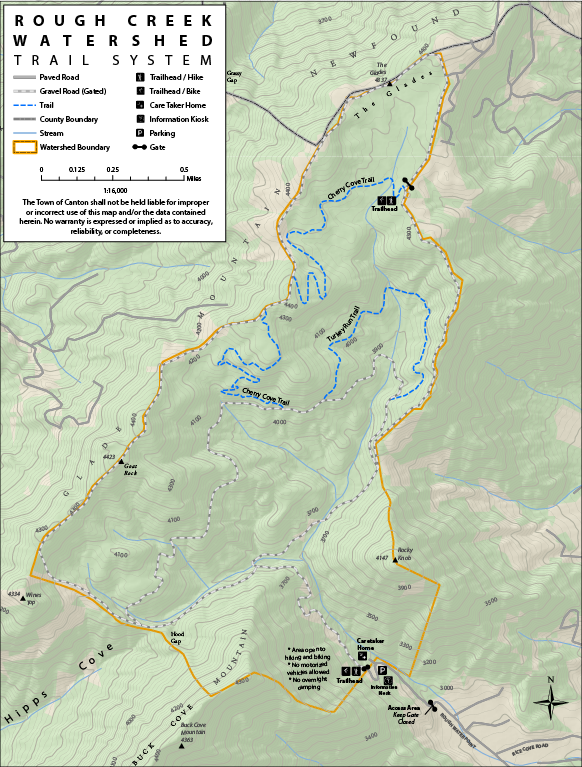
PARK MAP
A large format map can be found on site or click the image below to download or print a copy.
Enjoy the History, Ecology, and Beauty of Canton and Haywood County
The Rough Creek Watershed property, located at 265 Rough Water Pt., consists of over 870 acres of beautiful & majestic land, owned by the Town of Canton. This property is located on the south side of the Newfound Mountain Range, approximately 5 miles north of Canton in Western North Carolina. The Rough Creek Watershed Trail System is comprised of 3 trails of various distances, totaling 10+ miles.
This immense natural resource is open to the public for hiking and mountain biking year round!
TRAIL DESCRIPTIONS
CHERRY COVE TRAIL
The Cherry Cove trail splits off the “inner” loop road and climbs to the “outer” loop perimeter road on the west side of the watershed via switchbacks. It then follows the “outer” loop road for a short bit along the ridge (with magnificent views), splits off again and descends through the lower portion of The Glades, before climbing the eastern edge of the watershed to again reach the “outer” perimeter loop road.
TURKEY RUN TRAIL
The Turkey Run trail splits off the “inner” loop road and joins back with it again at a point farther east, making yet another “inner” loop of trail.
A nice figure 8 hike can incorporate many of these roads and trails into one long, 10+ mile hike.
DIRECTIONS
265 Rough Water Pt., Canton NC
From the parking area below the caretaker’s house, access the trail by following the roadbed through the pasture to the gated entrance of the watershed. (Please note that the road goes through private property and leaving the road bed is PROHIBITED). CLOSE THE GATE and continue up the road to a signed intersection. At the intersection, go either left or right & follow the signs to the lower trail head for Cherry Cove Trail. On Cherry Cove Trail, follow the trail signs to the West Boundary Road. Go right on the road & rejoin Cherry Cove Trail where it goes back into the woods (a right turn). Cherry Cove Trail will end at the East Boundary Road. To return to the parking area, either backtrack on Cherry Cove Trail or turn right & follow the signs back to the entrance road.
PARK RULES
- Hiking & mountain biking are allowed only on designated trails;
- NO horses, dogs, or motorized vehicles;
- Remember, DO NOT leave the trails. Protection of the ecosystem & water quality is of utmost importance;
- Please try to avoid use of disposable containers within the watershed. Pack out what you bring into the Watershed;
- “Leave No Trace” practices are required. This includes leaving what you find & respecting wildlife & other hikers. Take nothing but pictures & memories & leave nothing but footprints.
- ONLY day use of the watershed is permitted;
- NO hunting, firearms, fishing or harvesting of plants allowed; &
- NO drug or alcohol use or other illegal activities are allowed.
HISTORY
The watershed was settled by early pioneers in the 1800’s. There were several home sites & a school within the watershed which can still be located by observing rock walls, areas of naturalized plantings, & apple orchards. The orchards are interesting as they contain many species of heirloom apples which have become rare due to development & the advent of hybrid breeds. Higher elevation areas were used for grazing livestock & apple orchards. Lower areas of the watershed were left wild, indicated by the old-growth hemlock trees flocking the lower slopes of the creek. By the early 1900’s, settlers had moved out & the Town of Canton designated the watershed as protected. From that point, very little human interaction occurred until selective logging in the 1970’s and 1980’s.
In 1979 the Society of American Forestry listed the area as an outstanding ecological site. On February 28th, 1997 it was certified as a North Carolina Registered Natural Heritage Area (NCRNHA), because of its unique Swamp Forest-Bog complex (Glades section) that contained many rare & endangered plants. Recognized in August of 2000, for its high quality water & both State & National ecological significance, the Rough Creek Watershed was classified by both the North Carolina Division of Water Quality & North Carolina General Assembly, as an Outstanding Resource Water (ORW).
In 2002, with the help of the Southern Appalachian Highlands Conservancy (SAHC), a partnership was created between the Town of Canton & the North Carolina Clean Water Management Trust Fund. This relationship has led to the establishment of a conservation easement throughout the Rough Creek property, ensuring the protection of its unique forest ecosystem & natural resources.
ECOLOGY
The Rough Creek Watershed is 870 acres of protected mountain land north of Canton, NC. It was closed to public access when it was used as a water resource for the Town of Canton. This area is an excellent example of near pristine ecosystems of the Great Smoky Mountain Region. It contains nearly 7 miles of streams, numerous seeps, springs, & swamp/bog areas which have become fairly uncommon with human inhabitants of the region.
The watershed contains many species of interesting & rare plants (painted trillium, whorled pogonia) as well as a large & diverse animal population (salamanders, turkey, bear, bobcats, songbirds). This diversity provides the residents of Haywood County, & particularly the Town of Canton, an opportunity to experience in their own backyard biodiversity similar to that found in the Great Smoky Mountain National Park.
The water found in Rough Creek Watershed is classified by the State of North Carolina as an outstanding water resource. The purity of the water rivals and often exceeds comparison to other protected waters in the state.